Springfield, Virginia
All of these are located in places easy to snarf & park.
All of these have been added to Markeroni.
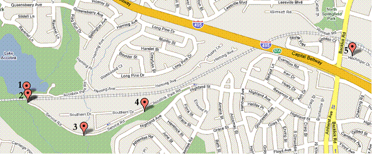
Markers 1-4 are at Lake Accotink Park. There’s a brown sign by one entrance announcing historical markers ahead. It’s easiest to enter at Highland St., bear left into the park, and continue on down the Service Rd. As of July 2009, there will be a charge for everyone entering the park (more for people who do not live in the county). Markers 1 and both 2s are located at the edge of a huge parking lot.
1. The Origins of Lake Accotink- big sign with history
Lat 38.7931 Long -77.21794
Marker is on Accotink Park Road east of Southern Drive, on the right when traveling west. From Backlick Road, take Highland Street west to Accotink Park (follow the signs).
2. The Orange and Alexandria Railroad Trestle- Fairfax County marker
Lat 38.79254167 Long -77.21778056
Marker is on Accotink Park Road, on the left when traveling east.
2. Orange and Alexandria RR- Civil War Trail table
Lat 38.79254167 Long -77.21778056
Marker is on Accotink Park Road, on the left when traveling east.
3. The Civilian Conservation Corps- Fairfax County marker
Lat 38.7899 Long -77.2121
Marker is on Accotink Park Road near Southern Drive, on the left when traveling west.
The road at the intersection where this marker is located leads to the info/visitor’s center for the park. Plenty of parking.
4. Orange and Alexandria Railroad- BW-4 state marker
Lat 38.7918 Long -77.2059
Marker is at the intersection of Accotink Park Road and Southern Drive on Accotink Park Road.
Be careful when parking since this is at the entrance/exit to the park itself. Pull to the side so you don’t block anyone.
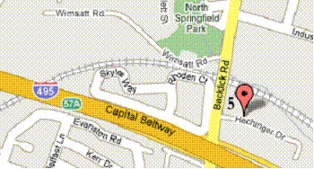
5. Springfield Station- Fairfax County marker
Lat 38.796223 Long -77.184738
Marker is on Hechinger Drive near Backlick Road, on the left when traveling east.
Since this is at the VRE train station, there is plenty of free parking right there at the marker.
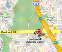
6. Ravensworth- T-42 state marker
Lat 38.809667 Long -77.221184
Port Royal Road is on the west side of the intersection of Braddock Road and the Capital Beltway (Interstate 495).
Since this is down Port Royal Road, on the edge of a shopping center, there is plenty of parking at the marker.
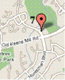
7. Keene’s Mill- Fairfax County marker
Lat 38.774801 Long -77.249409
Marker is on Huntsman Boulevard north of Old Keene Mill Road, on the right when traveling north into the townhouse development.
Parking is for residents only and the road in the housing development has no shoulder to pull off on. However, you should be able to park in a space visible from the marker, walk to the snarf, and get back in the space of a few minutes so there should be no danger of being towed.
Sources used: Markeroni, HMDB, Google Maps